SOLE Road Design
Automatically generates horizontal & vertical curves as per IRC standards, with super elevation, widening calculation, and detailed cross sections — all within AutoCAD.
- ✓ Horizontal & Vertical Curves
- ✓ Super Elevation & Widening
- ✓ Cross Section & Quantity
- ✓ L-Section & DTM Plans
- ✓ PCC & Drainage Design
- ✓ Auto Print & Export


Horizontal Curve
One of the most critical elements in road design. SOLE generates smooth, accurate horizontal curves as per IRC standards — ensuring safe driving at high speeds.
- ✓ Auto curve generation from alignment data
- ✓ Super elevation & widening included
- ✓ IRC compliant design parameters
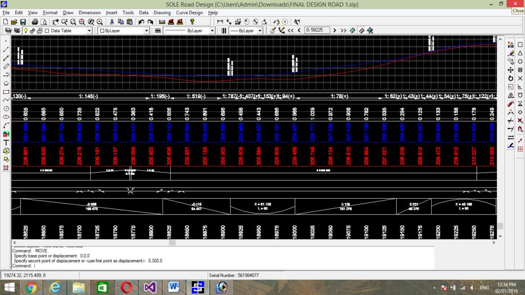
Vertical Curve
SOLE automatically calculates and draws vertical curves with all critical parameters — providing summit and valley curve data instantly for safe gradient transitions.
- ✓ Summit & valley curve generation
- ✓ Formation level export for site execution
- ✓ Design new or improve existing curves

Cross Section & Quantity
Draw cross sections with unlimited layers and calculate earthwork quantity precisely. Includes verification sheets for billing and estimation accuracy.
- ✓ Unlimited work layers & templates
- ✓ Auto quantity sheet with verification
- ✓ User-defined side slopes & berms
Packed with Powerful Features
Everything you need for road design, survey, and planning — all inside AutoCAD.
Road Design
- ✓ Auto Horizontal & Vertical Curve (IRC)
- ✓ Export formation level for site execution
- ✓ All critical road design parameters
- ✓ Super elevation & widening calculation
- ✓ Design new or improve existing curves
Survey & Terrain
- ✓ Template-based traverse & contour
- ✓ Smooth contour at custom intervals
- ✓ Customised DTM plan generation
- ✓ Fast & accurate interpolation
- ✓ Unlimited survey data support
Cross Section & Quantity
- ✓ Unlimited layers & templates
- ✓ Quantity sheet with verification
- ✓ PCC (Profile Corrective Course)
- ✓ Design-based work layers
- ✓ User-defined slopes & berms
CAD & Output
- ✓ L-Section with auto plan generation
- ✓ Drainage & retaining wall
- ✓ Full AutoCAD .DWG support
- ✓ Printer & plotter with preview
- ✓ Multi-page auto print facility
Meet SOLE Road Design.
Built for Excellence.
The ever-growing, multi-feature software. Fastest, most user-friendly, and built to generate top-quality modern road designs with precision.
20+ Features
Comprehensive road design toolkit
AutoCAD Native
Works with AutoCAD 2010 – 2025
IRC Compliant
As per Indian Road Congress standards